Project 03

Spatial Databases

Design and modeling of relational geographic databases. Conceptual UML schemas, relational models with primary and foreign keys, and spatial SQL queries with PostGIS.

SQL PostGIS UML PostgreSQL CDM

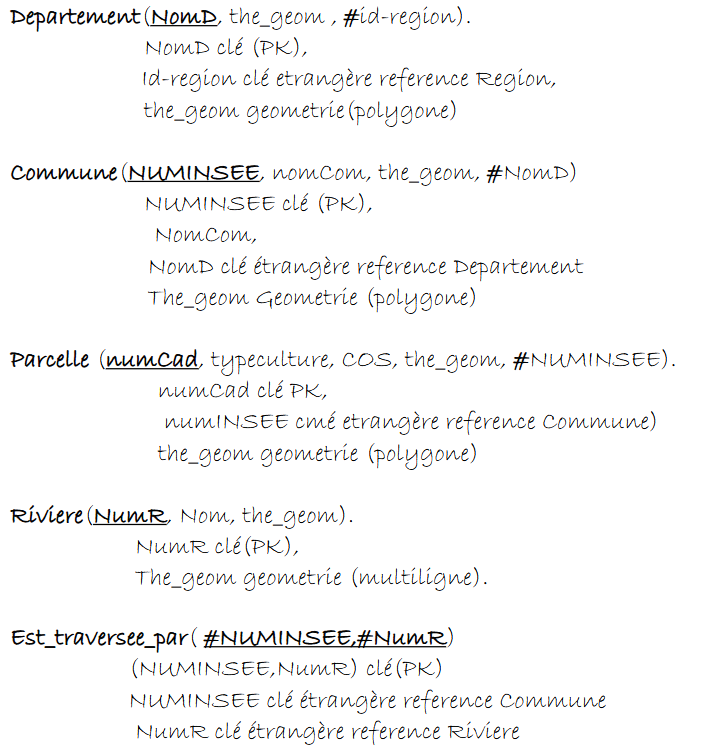
01 — Conceptual Data Schema (CDM)

The UML conceptual schema represents geographic entities and their relationships. Each entity has a geometry: Geometry attribute that stores spatial data (point, line, polygon) in PostGIS.

UML conceptual schema of spatial database

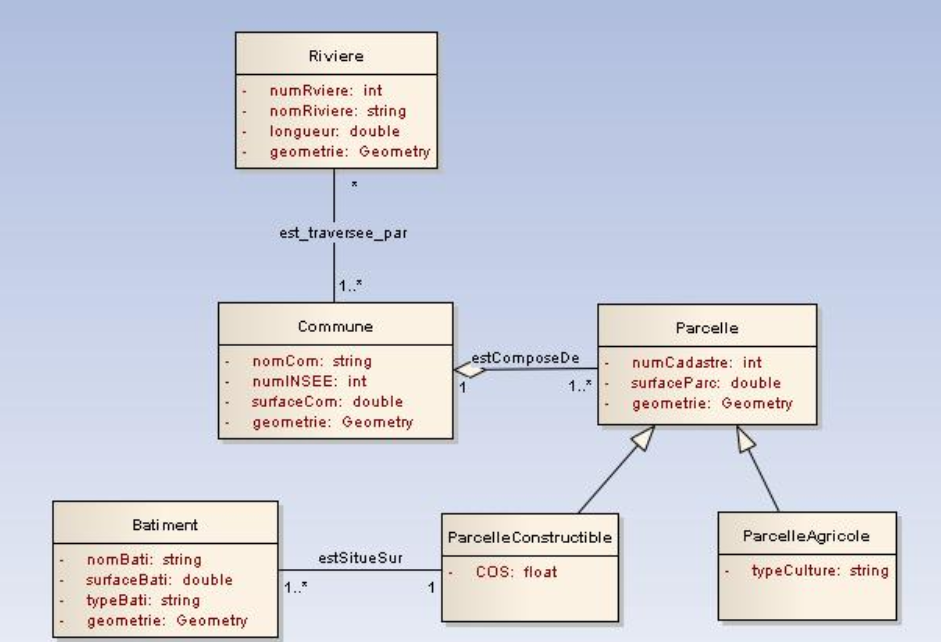
Fig. 1 — UML Conceptual Schema: River, Commune, Parcel, Building entities with inheritance and spatial associations

🔗 Key Relationships

River is_crossed_by Commune
Commune consistsOf Parcel (1..*)
Parcel ← ConstructibleParcel
Parcel ← AgriculturalParcel
Building isLocatedOn ConstructibleParcel

📐 Geometry Types

GEOM River MultiLineString
GEOM Commune Polygon
GEOM Parcel Polygon
GEOM Building Polygon

02 — Logical Data Model (LDM)

The relational model translates the conceptual schema into SQL tables. Primary keys (PK) uniquely identify each record, foreign keys (FK) ensure referential integrity between tables.

Relational schema of the database

Fig. 2 — Logical data model: tables, primary keys, foreign keys and geometries

PK Primary Key
FK Foreign Key
GEO Spatial Geometry

Departement

PK NomD string
GEO the_geom Polygon
FK id_region → Region

Commune

PK NUMINSEE int
nomCom string
GEO the_geom Polygon
FK NomD → Departement

Parcel

PK numCad int
typeculture string
COS float
GEO the_geom Polygon
FK NUMINSEE → Commune

River

PK NumR int
Nom string
GEO the_geom MultiLineString

Is_crossed_by

PK FK NUMINSEE → Commune
PK FK NumR → River

03 — Spatial SQL Queries

Examples of SQL queries using PostGIS spatial functions to query and analyze geographic data.

Communes crossed by a specific river (spatial join with ST_Intersects)

SELECT DISTINCT(c.nomCom)
FROM Commune c, River r
WHERE ST_INTERSECTS(c.the_geom, r.the_geom)
  AND r.Nom = 'Le Lez';

Communes of a given department (attribute join)

SELECT c.NomCom
FROM Departement d, Commune c
WHERE d.NomD = 'Languedoc-R';

Vineyard parcels of a commune (attribute filter)

SELECT numCad
FROM Parcel
WHERE NomCom = 'PradesLeLez'
  AND typeculture = 'viticole';

Herault communes neighboring Saint-Mathieu (ST_Touches = share a boundary)

SELECT c2.NUMINSEE
FROM Commune c1, Commune c2, Departement d
WHERE d.nomD = 'Herault'
  AND c1.NomCom = 'SaintMathieu'
  AND ST_TOUCHES(c1.the_geom, c2.the_geom); -- share a boundary

Hosted on Codeberg • 100% Open Source

← Back to portfolio